Thursday, August 28, 2008

Rain, Rain, Rain

Strip Mining, Breaks Interstate Park (KY/VA), Terrifying Coal Truck, Appalachian Trail Coming Into Damascus


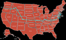
I'm in Damascus about 100 miles east into VA pretty much where NC, TN, and VA converge. Damascus is one of those little gems that you're fortunate enough to stumble upon every so often. The Appalachian Trail, TransAmerica Bike Trail, confluence of several dam release rivers, and a large cave system....long story short it's an outdoor mecca full of some really interesting and unique folks. Last night in the little town bar locals showed up with fiddles and banjos. I've heard the songs before but never quite played like I heard them last night. Also one of those bars where someone buys you a drink just because you're sitting next to them, very friendly indeed. So friendly that I opted to take a rest day today first one since CO. I hiked a few miles on the Appalachian Trail, worked on the bike which was in bad bad shape (new brake pads, rear tire, cables), did laundry, and my favorite part of the day called up Continental and cashed in some miles for a round trip ticket to Istanbul leaving September 8. I figure after this I'll need a vacation prior to whatever is next :) It's been raining pretty much 24/7 the last four days so taking today off was pretty easy and so far extremely enjoyable. I'm staying at a cross between a B&B and hostel in Damascus so interesting people to chat with there as well. Since last posting I can happily confirm that Hazard, KY is indeed the same as that from Dukes of Hazard....many General Lees and no shortage of Boss Hogs, Couters, and such although no Daisy. The last several days I've been riding through the coal belt that straddles KY, VA, TN, and I guess to some extent OH and NC. I've been pretty fortunate to travel around the world and see quite a bit but no where have I seen a practice more devastating to the environment than Strip Mining. You've heard the commercials, 50% of our electricity comes from coal these days it's being referred to as "clean coal", yeah right. To simplify they lop the entire top of a hill / mountain off to get to narrow bands of coal. When done they simply plant some strain of grass that dies quickly as there's no top soil. Erosion is horrible as are all sorts of heavy minerals winding up in the water supplies and crops. Sometimes they blast off huge tracts of land which cracks locals peoples water wells. You get extremely dirty riding around this area everything is covered in coal dust or now that it's raining coal sludge. I could go on and on. I spend a lot of time at gas stations (laughing at people paying $3.65/gallon) getting a drink or candy bar or whatever and I always talk to the people hanging out. To put it real blunt one old guy said, "we shit on our own plate". No idea if this is accurate but the figure thrown out is only 1 in 500 people locally benefit financially from mining. Perhaps the worst part is that the older folks walking around hacking and wheezing as result of old style coal mining as well as the young ones are out of work because this new method of strip mining is so much more EFFICIENT. Of course the coal needs to be transported, the coal trucks in this region are far more terrifying than the log trucks were, they certainly make every effort to avoid you when they can see you but the roads are so crooked and steep in the Appalachians that often they don't see you till they are directly behind you and of course there is little or no shoulder. So far I've always heard them coming and aside from minor scares it's not been an issue. The dogs are still chasing me but as it's been several hundred miles and countless encounters that I really don't give it much attention anymore. Of course I still speed up and try to avoid them but I've come to the conclusion that chasing bikes is a game for them and they'll get really close but they don't want to get run over as much as I don't want to get bit. Aside from the strip mining the Appalachians are gorgeous! Extremely lush, ensconced in fog, loaded with very small family farms. I don't think anyone really travels far and it doesn't seem like many work. It's a very different type of riding than the Rockies much steeper more curvy worse road surface generally quite a bit more violent normally ending up with me standing up on the pedals dripping in sweat or rain it's been hard to distinguish. Overall I'm enjoying riding in Appalachia the most so far maybe because I've never been as bicycle fit as I am at the moment, not sure. I've got roughly 2 more days in the Appalachians followed by a gradual downhill to Yorktown. Attention all ice cream truck drivers: your time is getting short very short!!!

Monday, August 25, 2008

Lincoln - Dry, Moist, Wet

A Lincoln Boyhood Home, Typical Eastern KY Road, Turtle Rescue, Crossing Ohio River


It's been incredibly humid since crossing the Mississippi a little better today but still pretty bad. I'm currently in Booneville, KY with hopes of making it to Hazard, KY this evening. Not sure if that's the Bo and Luke Duke town but we'll see. Last Thursday I crossed the Ohio river by Ferry into KY. On the IL side the city was Cave In Rock named for a massive cave that water eroded in the limestone. On the KY side it was immediately Amish country, they are very much intrigued by the cyclists passing by and it was very enjoyable talking with some of them, I made certain to let them know that I love electricty, cars, and such....some of them do too. Friday I camped at Falls of Rough, KY really just a large reservoir tourist type spot. Friday was the last night that I camped as the humidity has been unbearable although that's not what I was referring to in the title. In KY there are counties and/or towns that do not sell alcohol; Dry is nothing, Moist is only in restaurants / bars, Wet is normal. I very much realize that I'm smack in the middle of the Bible Belt but I must admit I do not feel any more virtuous in the Dry areas. On the positive side I do see much less roadside litter in the Dry areas. The amount of beer cans on the side of the road in KY is alarming....Bud Light is certainly the most popular. Saturday was Falls of Rough to Bardstown where I began to get caught up in the Lincoln triangle. Turns out that Abraham Lincoln was born in KY and spent his first 14 years here. Perhaps just me but I always thought he was from IL.....The Land Of Lincoln, actually he moved to IL at 35 to run for Senate sort of like Hillary Clinton "comes from NY". Anyway, there are at least 5 boyhood homes of Lincoln along with the birthplace the place he almost drowned, the tree he fell out of, etc.... His family moved around Hodgenville, KY quite a bit. Early on KY was never surveyed well and folks were constantly battling over clean land deeds the Lincolns always seemed to loose. The Lincolns moved to IN when Abraham was 14 as result of his father being outspoken on slavery. Day 40 of this trip, yesterday, was from Bardstown to Berea, passed a few more Lincoln homesteads....at this point the Lincoln thing is getting a bit silly. He was born in 1809 so of course the big bicentennial is approaching. Last several days the roads have been really small one laners meandering around little hills or knobs. This morning those little hills have been getting larger as I'm entering into Appalachia the last mountain range of this trip. I'm giving up on roadkill pictures as the humidity is making them too disgusting even for me. Instead I'm shifting to preventing roadkill by removing turtles from the road so far I'm up to 13......they probably crawl right back as soon as I leave. Earlier today on roughly a 3 miles stretch I noticed that just about every mailbox had the same last name, must be chaos for the Postal Service. Onward!!!

Thursday, August 21, 2008

Popeye's Birthplace

Mill at Alley Springs, Crossing the Mississippi into Illinois, Popeye, Little levee along Mississippi


This morning I'm in Carbondale, IL having a bit of a lazy start. If I ever get moving today I'll end up taking a ferry across the Ohio river into Kentucky at Cave in Rock, I'm guessing there's a big hole in a rock there but weird name for a town. I've made it out of the Ozarks a bit grueling although really enjoyable riding. Alley Springs turned out to be pretty neat, MO #1 tourist spot for photos and such on any MO tourist propaganda Alley Springs is on the front page. Heading through southeastern MO I began seeing many confederate flags....somewhat amusing as they're predominately flying in front of the most dilapidated ratty trailers I've ever seen and from what I can tell the people living in them are pretty angry. On the off chance that any toothless confederates are reading this I think bleeding gums, marrying your cousin and outhouses are really cool. I've also been getting chased by many confederate dogs an entire pack yesterday.....not sure what they feed them in these parts but they are amazingly speedy. Yesterday I crossed the Mississippi leaving MO into Chester, IL. Turns out that Popeye was born in Chester, IL a town that also claims to have sent out Lewis and Clark on their journey (they did cross the river from Chester), there are more statues and pictures of Popeye then people in Chester. I got a burger in Chester for lunch and tried out the "I'll gladly pay you the second Tuesday of next week for a burger today"....they did not find it funny and I left town quickly. After Chester I rode a portion of the levee system along the Mississippi. Where I was at it was comprised of three levees the closest to the river being the lowest which I thought was backwards. Each levee had huge valves about every 1/2 mile or so to regulate the water. In the picture above you can see the left side is still flooded and was unable to be planted while the right side is planted. This was the case the entire way on the outside set of levee resulting from the flooding a few months ago. I finished week 5 off on Tuesday at just over 3,000miles with about 1,200 more to go.

Monday, August 18, 2008

Name That Critter

Name that critter, they've pies in MO too, typical rollers in the Ozarks, this game went on for hours


An hour or so after my last posting I experienced my second mechanical disaster. I managed to suck up a piece of steel belt tire into me rear derailer. Most unfortunately I didn't stop pedaling in time and the rear cog blew up. I ended up turning the bike into a single speed and heading for Hutchinson KS where there was a bike shop. By the time I reached Hutchinson it was getting dark so I pitched my tent on the outskirts of town and went to sleep. Around 3AM I woke up to crackling thunder lighting and buckets of rain. Ended up pretty wet by morning....good times! Managed to get the bike fixed Thursday AM and headed to Eureka KS. Along the way I passed George Washington Carvers initial homestead where he performed much of his early agricultural experiments. The terrain began getting hillier and greener as I moved into the Flint Hills section of eastern KS. Day 31 of my journey was from Eureka KS to Pittsburgh KS. Terrain continued to get hillier and greener with really fun hills where you could carry your speed from one to the next. Temperatures and humidity last few days have been perfect. Early Saturday morning I finally left Kansas after 580 miles and entered into Missouri. Never really thought much about MO but it's a beautiful state full of great hardwood leafy trees, lakes, and rivers. MO also has the northern half of the Ozarks which is the only geological uplift feature between the Rockies and the Appalachians. Needless to say the entire southern half of MO which is where I'm passing through is a roller coaster. They're not too high topping out at around 1,700ft but nothing is flat it's continually going from 200ft to 800ft back to 300ft and up to 1,500ft and so on....it's really fun riding but grueling. All the towns are very small with I'm guessing under 500 people but all seem to have at least 5 churches. I'm currently in Summersville pretty much in the middle of MO. I think I'll be crossing the Mississippi Wednesday afternoon. I'll spend some time this afternoon checking out Alley Springs. I'm told under most of MO there's an enormous aquifer filtering through limestone caves. Well, all this water shoots out at Alley Springs. No idea, more on this later. I'll spend this evening camping along the Current River in Eminence. Two random tid-bits. 1) I used to love q-tips....I've now gone 31 days w/out them and have come to the conclusion that they aren't not necessary, I can still hear just fine. 2) Bike locks....I've now carried a two pound bike lock something like 3,000miles and not used it once, either folks don't like fluorescent green or they're good honest people that don't steel, I believe the latter (I hope I don't get proved wrong). Best for last: something really wonderful happened a few days ago. Many of you reading who know me well know that I've got some issues with my feet. Particularly claw like nails and a few mangled toes. Not quite sure why but guessing as result of the pressure from my cycling shoes over so many days one of my two "claws" loosened and with a few minutes work tinkering with the pliers on my leatherman I was able to pop it off underneath was/is a wonderful see through nail not yellow crumbling or a 1/4 inch thick. I have high hopes that the other claw will pop off too. In closing I am very happy to see that I've at least one road kill fan. I've instituted a new game, "name that critter". Perhaps in the future all this collaboration on this interweb thing will allow one to post smells too...that would really make "name that critter" a world class game.

Wednesday, August 13, 2008

The Road Curved Today

Mini Oil Derrick, Grain Elevator, Unlucky Snake (bonus points if someone looks up what type of snake this is and if it's dangerous....cotton mouth???)


First time in several days. The roads in Kansas are laid out in a grid pattern I keep making lefts and rights as I'm sort of going diagonally southeast across. I'm pretty certain that I'd be in a Missouri by now if they only had a diagonal road. Anyway earlier today the road actually curved I was a bit concerned that my handle bars were stuck in the "straight" position but all worked out just fine. It's getting hotter, more humid, and much greener. Roughly around Great Bend, KS (where the AR-Kansas river makes a left hand turn) the yearly rain average triples and crops shift from sunflowers and wheat to corn and cows. By the time I leave KS I'm certain I will have eaten an entire cow....there's nothing else except for the pies which come in all fruit varieties I've been sampling several a day. I passed through the Quivira National Wildlife Refuge this morning, aka...great big mosquito breeding ground. All the various bug noises and such were pleasant that's about it. The new scary thing are snakes in the road. Mostly lurking on the shoulder half in the grass and half in the road. I guess in the morning a warm road is like a sauna to a snake. I accidentally ran one over this morning. In just about every field in Kansas there is a mini oil derrick. For the last 75 years or so oil companies have renewed mineral right leases but not actively drilled since the operations are fairly small until a year or so ago not profitable. Today everything is being drilled every other truck on the road is transporting oil. The other half of the trucks are moving grain...Kansas really does feed the world. Every little town has a grain elevator along the train tracks (sometimes that's the town) and that operation never stops at least not in the several days that I've been riding through. The people in Kansas continue to be the highlight of the state pretty much the nicest folks I've met and equipped with great pie making skills. I should make it into Missouri sometime Friday afternoon.

Monday, August 11, 2008

Should Have Carried A Spare Tire

Bad weather around Pueblo CO, Latest roadkill favorite (very white teeth), many sunflower farms in western KS, Clarence


Despite Steve's best wishes I made it out of the Rockies in one piece. Friday morning was about as perfect as it gets; wind was coming from behind, road was bran new with an excellent shoulder, temperature right around 70'F, and great scenery. I admit the forecast and surrounding low black clouds were ominous and I knew I'd run into the storm at some point but that didn't happen till the afternoon. I crossed the Continental Divide for the 10th and final time at Current Creek at around 9500ft. By 2PM I had descended about 5000'ft Canyon City is where all hell broke loose. Pretty much per the weather forecast Steve posted. I made it to Pueblo that evening and got a hotel room. Saturday was rain off and on made it Eads, CO. Sunday was scattered rain again I made it to Scott City, KS and changed the clock to Central Time Zone. I'm still amazed at the level you witness the terrain and such change when traveling by bicycle. Eastern CO is pretty boring in every aspect, very dry and dusty. I'd been noticing over the last few days that my rear tire was shredding in a few places as result of the horrendous roads in eastern CO. Yesterday afternoon I began getting flat after flat but as I wasn't carrying a spare and no where to buy a new one I had to hope for the best. This morning 20 miles into the day my rear tire blew up. I was on a small rural road but within 10 minutes three different trucks stopped all with ideas on what to do. Very long story short I ended up spending the day with Clarence Bryant (what are the chances of that) a retired wheat farmer. At this point I'm only about 40 miles east of where I started the day but I've got two brand new tires and feel very good about the world after a day with Clarence. I'm loosely following the Trans America Bicycle Trail inaugurated in 1976 when several thousand bike enthusiast / flower power types set out from Astoria OR to Yorktown Virginia. Kansans very much remember that trip and to this day go out of their way to do anything in their power to help or make passing cyclists feel at home offering all types off assistance and encouragement. They are really great! I guess lesson for today should be carry a spare but if I had I wouldn't of got to spend the day with Clarence (I"m not carrying a spare).

Thursday, August 7, 2008

Hail Hurts & Relaxing in Conifer, CO

Black Bear Roadkill, Dillon Reservoir, Hoosier Pass, The Moran's; Steve (lived with in college), Karen (wife), Sara (daughter), Jimmy (son), Morgan (St Bernard #1), and Cherry (St Bernard #2), It was supposed to be restful...:)


Monday evening I ended up in Walden, CO which is in the middle of North Park basically a high plateau surrounded on three sides by between 12-14,000ft peaks you really get a feel for the terrain when riding in (slowly) on a bicycle. North Park at one time was jammed with buffalo now all gone but still abundant wildlife particularly; elk, deer, black bear, and birds it's very good grazing so no reason for the critters to go elsewhere (plus they probably don't like to climb either). I camped out in the city park! Tuesday morning while riding out of North Park I got recruited to stick around and work for a few days "bringing the hay in", they've a dramatic shortage of labor in North Park (people are moving out the school went from 350 last year to 175 this year, no jobs)....I declined. They're exploring for oil in North Park, of course some like it some don't. I had no idea that when you buy land you're only buying surface rights unless you've specifically contracted for the mineral rights below. Seemed that majority of land owners in North Park only have surface rights and our accepting payments from the oil companies for "access rights". Consensus from the few I spoke with was that they aren't really excited about the upcoming drilling and such but can't say no to the money. Leaving North Park heading up over Willow Creek Pass (CD#8 9,621ft) you begin to see large tracts of Pine trees that are brown and dead as result of abnormally high beetle infestations, if you buy into global warming you would say that the lack of really cold winters lately is allowing the beetle population to sky rocket. The dead trees continue to get worse as you head east. I've been seeing diverse and disgusting road kill in various states of decay the entire trip but towards the top of Willow Creek pass I was blown away by a teenage black bear lying on the side of the road....I'll post a pick just to give you a feel sorry if some find it disgusting. Tuesday night I camped at Green Mountain Reservoir just south of Kremling, CO (good swimming). Wednesday began with great weather and very picturesque scenery as I was beginning to ride into Middle Park and "ski town country"; Silverthorne, Dillon, Keystone, Breckenridge along the way. Excellent bike path from Silverthorne to Breckenridge. After Breckenridge I climbed the highest point of the trip, Hoosier Pass at 11,542ft (CD#9) all hell broke loose as I approached the top. Riding up really wasn't that bad the grade was pretty gentle probably around 4% and by that point I was pretty acclimatized to the altitude. Approaching the top I had my eye on a very black sky with clouds moving really quickly. Within 10 minutes the temperature went from 73'F to 42'F marble size hail mixed with rain began to pound me on the descent. After a few minutes I could no longer feel my fingers which coupled with wet rims and brakes made slowing down really hard. Aside from my legs which wasn't an issue my ears were exposed. Ears are very sensitive to marble sized hail. While trying to cover up my ears with my rain jacket collar I had my first crash of the trip....not all that serious but I did smash my hip and arm against the pavement. Anyway following 25 miles or so of this misery I was in Fairplay (this is the heart of South Park so naturally everyone is nicknamed; Kenny, Kyle or Cartmen). where I was to be picked up and shuttled to Conifer for a day of rest at the Moran's. I walked into the only bar in Fairplay dripping wet and really cold wearing my funny bike apparel changed in the bathroom and sat next to a guy wearing spurs at the bar waiting for Steve to get off of work and pick me up. It was raining and cold so the spur guy had given up for the day and was planning on getting the cows together tomorrow. Steve shows up around 5PM and I decide along the drive to his house in Conifer that I would have been really upset had I opted to ride the 50 miles or so.....extremely hilly. Tomorrow morning I'll get dropped off where I got picked up so not missing anything. I certainly needed the rest and am really really glad that Steve and family are in the area. I'm spending today working on the bike doing laundry and such. Yesterday was three weeks into the trip, I've made it 1820 miles with roughly 2200 more to go. I'll be crossing the CD one more time tomorrow followed by 5000ft descent into Pueblo CO and another 5000ft very gradual descent to the Mississippi river somewhere in Missouri, I think.

Monday, August 4, 2008

Bye-Bye Wyoming Hello Colorado

Wine Cellar / Bomb Shelter, Home On The Range, Route 80, Two Story Outhouse


I'm in Encampment, WY an old mining town about 30 miles north of Colorado. Following three 110mile plus extremely windy days sleeping in some really odd places I checked myself into the Saratoga Hot Springs Spa last night....I avoided the mud bath but did go for a massage. My legs are feeling rather gelatinous so not thinking I'll make it very far today, really just want to get out of WY so probably only to Walden, CO on the edge of the Arapaho Wildlife Refuge (should be some pleasant camping). It's been non stop climbing in the wind going up from one plateau to the next the worst was a 23 mile climb up to the Beaver Plateau where I stayed with Bob at the "Home On The Range" in Jeffrey City. I met Bob while waiting for one way traffic through a construction zone at Togwotee pass two days earlier, he said "if you make it to Jeffrey City look for the yellow wind mill and you're welcome to stay with me". Bob's great great grandfather built the first homestead in Freemont County WY and 150 years or so later on his vacations Bob from Tacoma is renovating it so when he retires he can run it as a B&B. It's a really neat place right down to the autographed Roy Rogers picture...the place is loaded with that type of stuff. Too much to jot down here but the evening with Bob spanned visits to an old Indian graveyard (really spooky), collecting sea shells since a gazillion years ago the plateau was an ocean, some home made liquor, some of the brightest star gazing (of course there's an observatory at "Home On The Range" and sleeping in a wine cellar / bomb shelter. 40 years or so ago Jeffrey City was a major uranium mining town, Three Mile Island put a damper on the that but given recent events they are hopeful that the uranium mines will open back up. Anyway Bob's grandfather built a bomb shelter under the guise of a wine cellar as not to scare his grandmother. Left Jeffrey City early Sunday morning for yet another wind nightmare, at this point it's a ridiculous situation that I was getting used to and if it were happening to anyone else I'd find it amusing so for whatever reason I was no longer annoyed and just cranked through it. By 11AM I had crossed the Continental Divide twice (7 times total so far). Heading into Rawlings I met up with a group that was riding across the country with a film crew documenting their trek for a movie (I'm going to be a movie star more on that later / check them out at http://www.bikingthestates.com/). In Rawlings I had to get on a section of route 80 for about 20 miles to Walcot. This is the only section of the trip where I will be on a major road. Getting onto to 80 there were all sorts of high wind advisory signs.....but, this time for whatever reason I had the wind to my back. I hit 43 miles per hour got two flats (rear tire and the trailer...I never get flats on the trailer). The hot springs spa last night was great it was a real spa not just the routine tubs next to the river in the middle of nowhere, different but great. Over the next several days I'll be riding at between 9,500 - 11,500ft so I expect I'll be going pretty slow, except on the downhills :) Notes on the pictures 1) the windmill fills two huge tanks of water (where I got a bath) given the wind that day the tanks filled in 3 hours normally takes over 24 hours 2) look at the windsock I was finally going the right direction 3) two story out house raises the obvious question "where does the stuff from the second story fall ......took me a bit to figure this one out but during the winter with a heavy snow pack the bottom is not accessible so they just flip up the seats and everyone goes to the second level which during the summer I would hope is off limits.

Saturday, August 2, 2008

Wyoming Is Difficult

Togwotee Pass, Typical Wyoming Landscape, Mystery Animal, Worst Camping Site, Click On Picture To Learn About The Winds


I'm in Lander, WY taking a break from the heat and wind. Gone about 45 mile this morning with another 45 to go trying to get to Jeffrey City. Yesterday was tough, left Jackson around 8AM all was well until beginning the 28 mile climb up Togwotee Pass at 9658ft and yes again over the Continental Divide. The climb wasn't really the issue rather the wind which was relentless and the road is under construction so gravel, sand, tar, etc... for a few miles a pick up truck shuttled me as it was not rideable. It's real hot too! I've had brutal wind in my face every mile since leaving Jackson. On the positive side there are nice multi colored rock cliffs in Wyoming. Last night was without question my worst camp site, ever, behind the Crowheart Volunteer Fire Department. Oh, another bonus yesterday was the smoke...I've seen it for weeks but yesterday I was getting teary eyed from riding through it as well as some ash on my shirt (there is a fire in Pineville about 50 miles away). Town names are great; Crowheart comes from when the Shoshoni Indians fought thier last great battle against the Crow and the Shoshoni Chief figured the Crow Chief fought well so he hacked out his heart and put it on top of a stake and planted it on top of a hill, Sweetwater comes from when a wagon of sugar fell into the river, could go on and on but I'll spare you. Yes, they did name the Wind River and reservation in honor of the never ending wind which apparently enbales sheep and such to eat all year round by exposing the lower portions of whatever plants can grow in this dust bowl. All that horror yesterday and still managed 112 miles. In case you're ever in the area they do not sell beer on the Wind River Indian Reservation (probably for a good reason). I visited Sacajaweas' grave this morning, it was along the road, pretty sad as no question that she saved the entire Lewis & Clark expedition during thier darkest hour which in turn resulted in the settlement of the NW and she and her people end up on a reservation comprised of dry dusty rocky windy crap. Arapahoes and Shoshoni share the Wind River Reservation but they were historical enemies, got to wonder if the grand plan was for them to get rid of one another....instead they now co-manage casinos, cow farms, and a few trinket shops. Off to lunch followed by more wind and heat. Final note for today - I'd sacrifice the sheep in a second if someone would turn down the wind machine.